Lea Zmurko: Long overdue storms for Thursday
The rain and thunderstorms from last night continue to move east in the early morning. Showers and some stronger storms are expected to move across parts of central MN and northwest WI through out Thursday morning. No severe weather is expected in the early morning storms, as the intensity will reduce by sunrise.
Conditions will clear in the early afternoon ahead of the next round of thunderstorms. We are expecting broken cloud coverage and temperatures in the low to mid-seventies for the middle of the day.
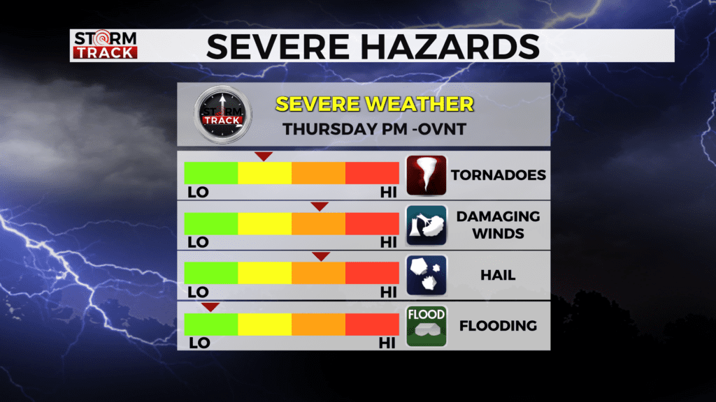
As we near the late afternoon and early evening, a band of storms will start to develop and pick up some momentum ahead of a cold front. This will likely bring scattered severe storms with risks of large hail, damaging winds, a couple tornadoes, and locally heavy rain across the Northland.
Once the rain clears, temperatures will fall to seasonable conditions for the weekend with increased cloud coverage and additional showers throughout the week remain possible.
Today
A chance of showers and thunderstorms, then showers likely and possibly a thunderstorm after 5pm. Some of the storms could be severe. Mostly cloudy, with a high near 78. Breezy, with an east wind 5 to 15 mph becoming south in the afternoon. Winds could gust as high as 20 mph. Chance of precipitation is 60%. New rainfall amounts between a tenth and quarter of an inch, except higher amounts possible in thunderstorms.
Tonight
Showers and thunderstorms likely, mainly before 8pm. Some of the storms could be severe. Patchy fog after 5am. Otherwise, mostly cloudy, with a low around 60. Southeast wind 5 to 10 mph becoming west after midnight. Winds could gust as high as 15 mph. Chance of precipitation is 60%. New precipitation amounts between a tenth and quarter of an inch, except higher amounts possible in thunderstorms.
Friday
Patchy fog before 7am. Otherwise, sunny, with a high near 77. West wind 5 to 10 mph, with gusts as high as 15 mph.
Saturday
A 40 percent chance of showers and thunderstorms after 1pm. Mostly sunny, with a high near 76. East wind 5 to 10 mph becoming south in the afternoon. Winds could gust as high as 15 mph.
Sunday
A slight chance of showers. Partly sunny, with a high near 64. Northwest wind around 10 mph, with gusts as high as 20 mph.
Monday
A slight chance of showers after 1pm. Mostly sunny, with a high near 64. Breezy, with a northwest wind 5 to 15 mph becoming east in the afternoon. Winds could gust as high as 20 mph.
Tuesday
A slight chance of showers. Mostly cloudy, with a high near 64. Northwest wind 5 to 10 mph becoming south in the afternoon. Winds could gust as high as 15 mph.
Wednesday
A slight chance of showers. Mostly sunny, with a high near 64. Northwest wind 5 to 10 mph.