Justin Liles: The above average temperatures will continue
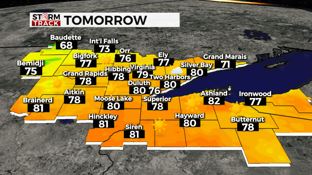
If you missed the northern lights last night you will get another chance to see the beautiful light display tonight. Our weather is being dominated by a huge ridge of warm summer like air sitting over Minnesota, Wisconsin, and U.P. of Michigan. Temperatures will remain well above normal through Sunday as many of us climb into the upper 70s to lower 80s.
This stretch of warm weather and sunshine is happening because of the merger of an upper level low and Hurricane Helene. A cold front is expected to cross over the region sometime early next week and will bring cooler temperatures back to near to slightly below normal and may bring rain showers back into the forecast.
TONIGHT
Mostly clear, with a low around 53. East wind around 5 mph becoming southwest after midnight.
FRIDAY
Sunny, with a high near 80. Southwest wind around 5 mph becoming northwest in the afternoon.
SATURDAY
Sunny, with a high near 77. Calm wind becoming northeast around 5 mph in the afternoon.
SUNDAY
Sunny, with a high near 71. East wind 5 to 10 mph, with gusts as high as 15 mph.
MONDAY
Mostly sunny, with a high near 76. Breezy, with a south wind 5 to 15 mph, with gusts as high as 20 mph.
TUESDAY
Mostly sunny, with a high near 60. Breezy, with a northwest wind 10 to 15 mph, with gusts as high as 20 mph.
WEDNESDAY
Mostly sunny, with a high near 65. Breezy, with a south wind 10 to 15 mph, with gusts as high as 20 mph.
THURSDAY
Mostly sunny, with a high near 62. Breezy, with a northwest wind 10 to 15 mph, with gusts as high as 20 mph.