Justin Liles: It’s not looking good for snowfall in the Northland
At this rate, this winter is turning into a complete bummer again. There is some snow in the forecast, but it’s not anything to get excited about. A cold front will begin to pass through Minnesota Thursday afternoon. Some light snow will accompany this front. We are not looking at any major accumulations. We will be lucky to get even a dusting. However, Thursday night conditions become a little more favorable for some snow that may stick around. Temperatures will stay consistent through the weekend. We are looking at temperatures staying in the teens for most of the Northland.
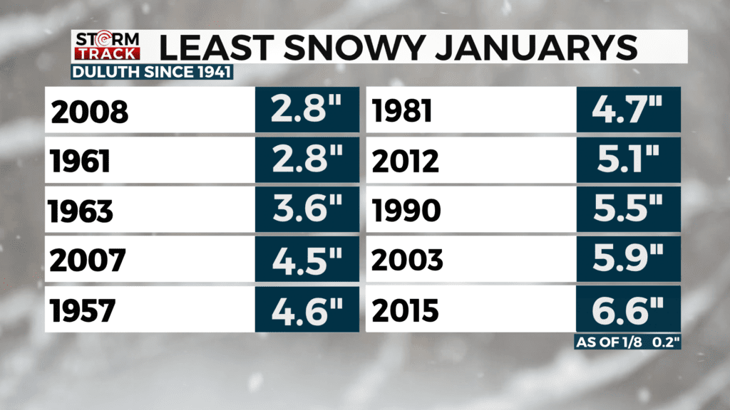
There is another chance of snow late Saturday into Monday morning. This end of the weekend snow will be our best bet to see any accumulation. Currently, during this time, it appears the heaviest snowfall of 2-4” is likely south-southwest of the Twin Ports. East central Minnesota and northern Wisconsin could see 1-2”. The pattern over the next two weeks does not look favorable for much snow. Let’s hope we see something and by the end of the month and we don’t end up in the top ten least snowy Januarys.

TONIGHT
Mostly cloudy, with a steady temperature around 9. South wind around 5 mph, with gusts as high as 15 mph.
THURSDAY
Light snow by Thursday afternoon. Mostly cloudy, with a high near 20. South wind around 5 mph becoming west in the afternoon.
FRIDAY
Partly sunny, with a high near 16. Northwest wind around 10 mph, with gusts as high as 20 mph.
SATURDAY
Partly sunny, with a high near 14. Northwest wind around 5 mph.
SUNDAY
A chance of snow. Mostly cloudy, with a high near 15. North wind 5 to 10 mph.
MONDAY
Partly sunny, with a high near 8. Northwest wind around 10 mph, with gusts as high as 20 mph.
TUESDAY
Mostly sunny, with a high near 9. West wind 5 to 10 mph, with gusts as high as 15 mph.
WEDNESDAY
Partly sunny, with a high near 20. West wind 5 to 10 mph, with gusts as high as 20 mph.