Justin Liles: Snow tracking south and east

Weak energy will continue to taper off across the Borderlands early this evening. The next weather story will be the chance for accumulating snow across NW WI Tuesday into Wednesday. A wintry mix of rain/snow arrives in the Northland Tuesday afternoon, with a chance for some light freezing rain to mix in for north-central WI Wednesday morning. The precipitation will transition to all snow Tuesday night. Accumulating snowfall is expected to begin Tuesday night and continue throughout the day on Wednesday. The greatest snowfall estimates look to be to our east. These areas include Ashland, Sawyer, Price, and Iron Counties. The greatest snowfall amounts are expected to be in these areas where 3-6 inches of snow.
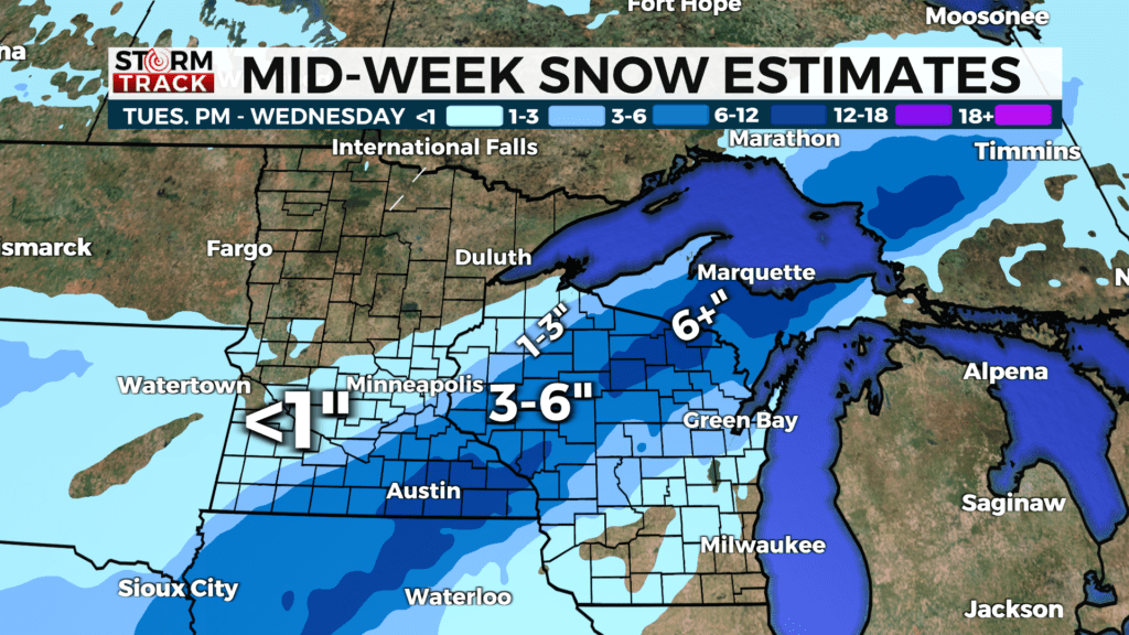
Please keep in mind snowfall totals may change due to the track of this system. It’s starting to look as if it will slide farther east. Along with this snow, gusty winds out of the northeast will develop Tuesday night through Wednesday evening. Falling snow combined with these increased winds could lead to blowing snow and poor visibility in these areas. Please continue to monitor road conditions by clicking the link. Temperatures will warm close to 50° or more by Friday. More snow is possible to our south again Sunday into Monday.
TONIGHT
Mostly cloudy, with a low around 26. East wind 5 to 10 mph becoming north in the evening. Winds could gust as high as 15 mph.
TUESDAY
A chance of sprinkles and flurries between 2pm and 3pm, then a slight chance of snow after 3pm. Mostly cloudy, with a high near 37. Breezy, with an east wind 5 to 15 mph, with gusts as high as 20 mph. Chance of precipitation is 20%.
TUESDAY NIGHT
A 50 percent chance of snow, mainly after 7pm. Cloudy, with a low around 29. Blustery, with a northeast wind around 15 mph, with gusts as high as 25 mph. New snow accumulation of less than a half inch possible.
WEDNESDAY
A 40 percent chance of snow, mainly before 1pm. Mostly cloudy, with a high near 40. Breezy, with a north wind 15 to 20 mph, with gusts as high as 30 mph.
THURSDAY
Sunny, with a high near 43. Breezy, with a northwest wind 10 to 15 mph, with gusts as high as 20 mph.
FRIDAY
Partly sunny, with a high near 49. Breezy, with a southwest wind 10 to 15 mph becoming west in the afternoon. Winds could gust as high as 25 mph.
SATURDAY
Sunny, with a high near 36. North wind around 10 mph, with gusts as high as 15 mph.
SUNDAY
A chance of rain and snow. Partly sunny, with a high near 40. Breezy, with an east wind 10 to 15 mph, with gusts as high as 20 mph.
MONDAY
A slight chance of rain and snow. Partly sunny, with a high near 42. Northeast wind around 10 mph, with gusts as high as 20 mph.