Justin Liles: Cold morning start followed by snow starting Saturday evening
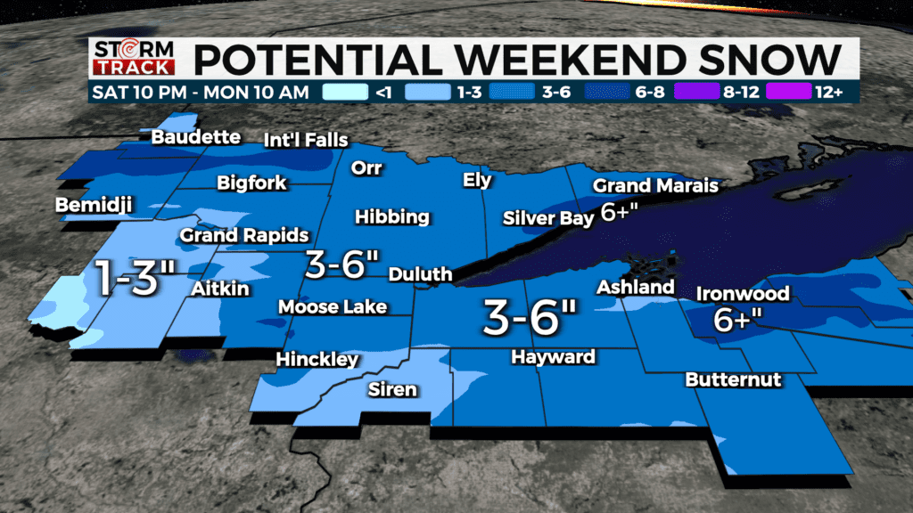
A system will bring more snow to the Northland this weekend. Snow and rain snow mix will begin Saturday night and last into early Monday morning. Areas that will see a mix will be across the southern half of the Northland. A Winter Storm Watch is in effect for the Arrowhead. The system that will bring snow still has a bit of spread. It’s looking more likely that most of the Northland will likely see as much as 3-6 inches of snow. The potential for totals over 6 inches is most likely in the Arrowhead and U.P. of Michigan.
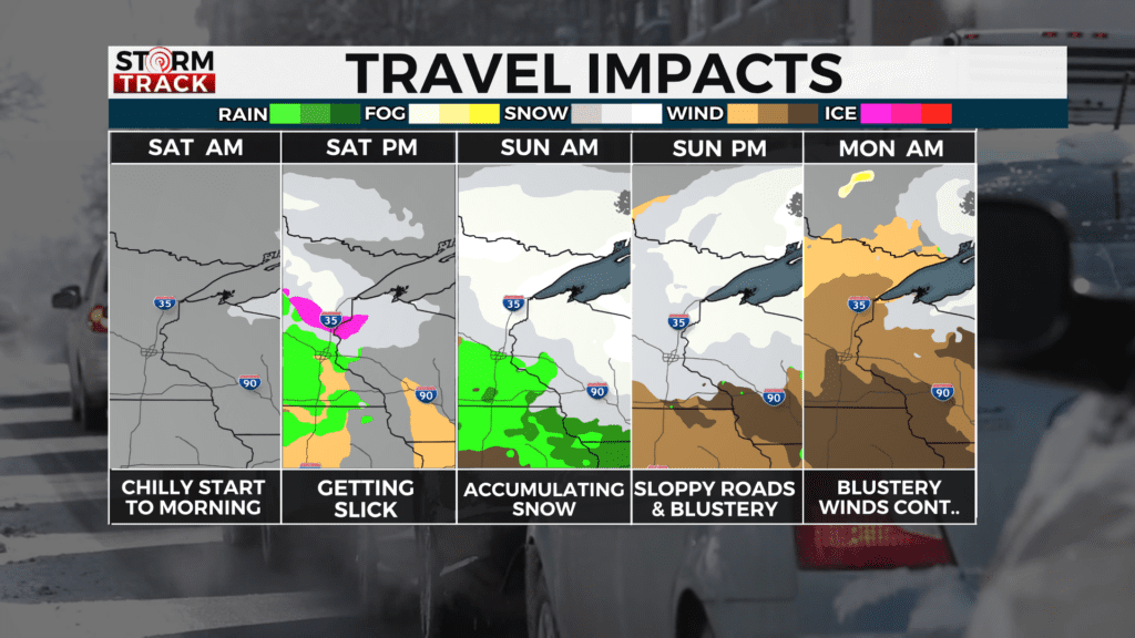
Travel will won’t be the best on Sunday too. Conditions are likely to deteriorate as the day continues. Accumulating snow and blowing winds spilled into Monday morning creating a slow start to the new work week.
SATURDAY
Sunny, with a high near 34. Light and variable wind becoming southeast 5 to 10 mph in the afternoon.
SATURDAY NIGHT
Snow after 1am. Low around 22. Breezy, with an east wind 10 to 15 mph, with gusts as high as 20 mph. Chance of precipitation is 90%. New snow accumulation of 1 to 2 inches possible.
SUNDAY
Snow, possibly mixed with rain, becoming all snow after 4pm. High near 37. Breezy, with an east wind around 15 mph, with gusts as high as 25 mph. New snow accumulation of 2 to 4 inches possible.
SUNDAY NIGHT
Snow likely. Mostly cloudy, with a low around 24. Blustery, with a northwest wind around 15 mph, with gusts as high as 25 mph. New snow accumulation of 1 to 2 inches possible.
MONDAY
Partly sunny, with a high near 38. Breezy, with a northwest wind 10 to 15 mph, with gusts as high as 20 mph.
TUESDAY
Partly sunny, with a high near 40. Northwest wind 5 to 10 mph, with gusts as high as 15 mph.
WEDNESDAY
Mostly sunny, with a high near 45. West wind 5 to 10 mph, with gusts as high as 20 mph.