Justin Liles: Wildfire smoke to end the week and getting hot
High pressure will dominate the Northland the rest of the week. This means conditions are going to be rather quiet. Wildfire smoke out of Canada will create hazy conditions the remainder of the of the week too. Most of the smoke will stay in the upper levels of the atmosphere and shouldn’t lead to any health concerns. As far as being able to smell the smoke, there might be a brief window of smelling the smoke.
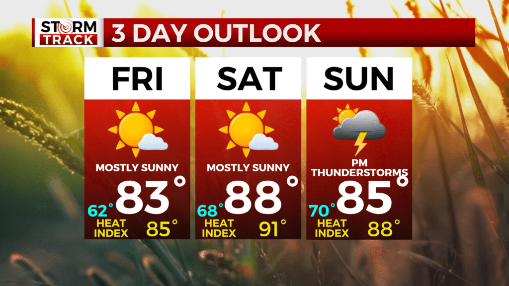
Temperatures will continue to increase all week as southerly winds take over. By Saturday and Sunday temperatures look to climb well into the 80’s. Dew points are expected to climb into the upper 60s to 70s making for uncomfortable conditions and not the greatest sleeping weather. Currently, heat indices could climb in the 90s. It’s going to be another find ways to stay cool and keep an eye out for one another. Strong storms are possible late Saturday. Sunday evening looks like some stronger thunderstorms are possible and could become severe.
TONIGHT
Mostly clear, with a low around 52. East wind around 5 mph becoming calm in the evening.
THURSDAY
Sunny, with a high near 79. Calm wind becoming south around 5 mph in the morning.
FRIDAY
Mostly sunny, with a high near 83. Breezy, with a south wind 10 to 15 mph, with gusts as high as 25 mph.
SATURDAY
Mostly sunny, with a high near 88. Breezy, with a south wind around 15 mph, with gusts as high as 25 mph.
SUNDAY
A chance of showers after 1pm. Mostly sunny, with a high near 85. Breezy, with a south wind 10 to 15 mph, with gusts as high as 20 mph.
MONDAY
A chance of showers and thunderstorms. Partly sunny, with a high near 84. South wind 5 to 10 mph becoming west in the afternoon. Winds could gust as high as 15 mph.
TUESDAY
Sunny, with a high near 86. West wind around 5 mph becoming southwest in the afternoon.