Lea Zmurko: A sunny start before the storms arrive
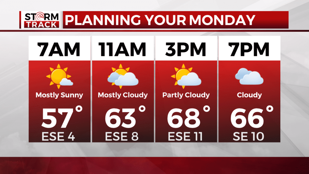
Scattered showers to start our Monday morning for regions in central and northern Minnesota. These will clear as the morning progresses and a mostly sunny afternoon will kick off our week.
Temperatures will increase to the low 70 for this afternoon and we will see a warming trend through this week.
As we move into the overnight, conditions will switch as more heavy rainfall moves into the Northland. Chances for isolated severe storms and thunderstorms for western Minnesota and through the Iron Range will last from 9PM to 1 AM tomorrow morning.
With at least an additional inch of rainfall expected in parts of northern Minnesota, a flood watch has been issued as water levels remain elevated and grounds are still soggy from previous rainfall events. The risk for flash flooding continues up through the Arrowhead as well.
Wednesday brings in dry weather as temperatures near 80 degrees and a west wind will keep conditions warm and breezy. Rainfall will return late Thursday and into Friday.
Today
A slight chance of showers between 7am and 11am. Partly sunny, with a high near 73. Breezy, with a south wind 5 to 15 mph, with gusts as high as 25 mph. Chance of precipitation is 20%.
Tonight
A chance of showers and thunderstorms, then showers and possibly a thunderstorm after midnight. Low around 54. Breezy, with a south wind around 15 mph, with gusts as high as 25 mph. Chance of precipitation is 90%. New rainfall amounts between a quarter and half of an inch possible.
Tuesday
Showers and thunderstorms likely before 1pm, then a chance of showers between 1pm and 4pm, then a chance of showers and thunderstorms after 4pm. Mostly cloudy, with a high near 75. Breezy, with a south wind 10 to 15 mph, with gusts as high as 25 mph. Chance of precipitation is 60%. New rainfall amounts between a tenth and quarter of an inch, except higher amounts possible in thunderstorms.
Wednesday
Sunny, with a high near 79. Breezy, with a west wind 10 to 15 mph, with gusts as high as 25 mph.
Independence Day
A chance of showers, with thunderstorms also possible after 1pm. Partly sunny, with a high near 76. West wind around 5 mph becoming southeast in the afternoon.
Friday
Showers likely and possibly a thunderstorm. Mostly cloudy, with a high near 70. Northeast wind around 10 mph, with gusts as high as 15 mph.
Saturday
A chance of showers and thunderstorms. Mostly sunny, with a high near 78. West wind 5 to 10 mph, with gusts as high as 15 mph.
Sunday
Showers and thunderstorms likely. Partly sunny, with a high near 76. Southwest wind 5 to 10 mph, with gusts as high as 20 mph.