Lea Zmurko: Rainfall totals continue to rise with early morning rain
Widespread showers arrived across the Northland late overnight. Moderate to heavy rainfall was brought to portions over northern Minnesota in the early hours of Tuesday. With an additional 1 – 2.5 inches recorded by 3 AM in certain areas; Flood Watches have been enacted as additional water will continue to elevate water levels in the region. The risk for Flash Floods will remain in place for parts of Koochiching, St. Louis, and Lake counties through the mid-morning today.
There will be a break in the rain by the later parts of the morning and Tuesday will remain foggy and mostly cloudy. Temperatures will make their way to the low 70s. Tonight a few isolated showers and thunderstorms will push across the Iron Range eastward onto the lake.
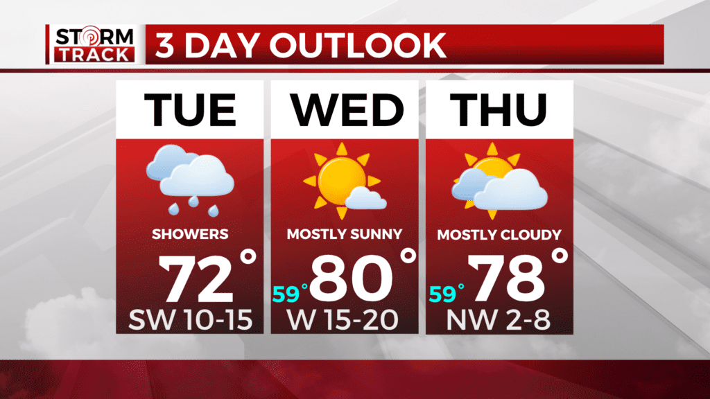
The sky will clear overnight and tomorrow will remain dry. The breezy conditions will persist with winds coming from the west. A warming trend will continue as temperatures climb into the low 80s.
Rain will return by Thursday evening with most of the storms trekking south of the Twin Ports and more rainfall is expected by the Twin Cities. Showers and storms will move in by Friday with another chance for heavy rainfall in the Northland.
Today
Showers and thunderstorms likely before 10am, then a slight chance of showers between 10am and 11am. Patchy fog between 7am and 1pm. Otherwise, mostly cloudy, with a high near 72. Breezy, with a southwest wind around 15 mph, with gusts as high as 25 mph. Chance of precipitation is 60%. New precipitation amounts between a tenth and quarter of an inch, except higher amounts possible in thunderstorms.
Tonight
A 40 percent chance of showers and thunderstorms, mainly before 9pm. Mostly cloudy, then gradually becoming mostly clear, with a low around 59. Southwest wind 5 to 10 mph becoming west after midnight. Winds could gust as high as 20 mph.
Wednesday
A 20 percent chance of showers and thunderstorms after 4pm. Mostly sunny, with a high near 77. Breezy, with a west wind 10 to 15 mph, with gusts as high as 25 mph.
Independence Day
A slight chance of showers, then a chance of showers and thunderstorms after 1pm. Partly sunny, with a high near 78. Northwest wind around 5 mph becoming southeast in the afternoon. Chance of precipitation is 40%.
Friday
Showers likely, with thunderstorms also possible after 1pm. Mostly cloudy, with a high near 70. Northeast wind 5 to 10 mph, with gusts as high as 15 mph.
Saturday
A slight chance of showers, then a chance of showers and thunderstorms after 1pm. Mostly sunny, with a high near 78. Southwest wind 5 to 10 mph, with gusts as high as 15 mph.
Sunday
Showers likely and possibly a thunderstorm. Mostly sunny, with a high near 76. West wind 5 to 10 mph, with gusts as high as 20 mph.
Monday
A chance of showers and thunderstorms. Mostly sunny, with a high near 76. West wind 5 to 10 mph, with gusts as high as 15 mph.