Utilizing drone technology in the search for missing persons
When there is a missing person in the area, St. Louis County Rescue Squad responds to the call. Captain Rick Slatten says the group did 69 searches for missing people last year.
“We roll drones, trackers. We call it our reflex toolbox,” said Slatten. “It’s the Phillips screwdriver, the vise grip, the hammer that you reach for in every search. And drones are part of that.”
In early March, drone technology helped the team find a missing man.
“We had a vulnerable adult. He had dementia. He had gotten out of a care facility in Proctor,” recalled Slatten. “Searches are solved by data. They’re not solved by luck. Good searchers go out and create their own luck by gathering and analyzing good data.”
The information they gathered led crews to the area around Highway 2 and Highway 33. Their focus was narrowed further with the help of the community.
“We canvassed neighborhoods and talked to other people who had seen this gentleman. And the more these data points pop up, the more they cluster in one area. That’s telling us, look here. So we put a drone in the air,” recalled Slatten.
Once it was in the air, it took roughly 15 minutes for the drone to help locate the missing man. The drone sent GPS coordinates, quickly pointing rescue teams in the right direction.
“That saved a life. Second stage hypothermic. He would not have survived the night,” said Slatten.
Location data is just one of the drone’s many features. St. Louis County Rescue Squad Sergeant Matt Rukavina is one of the drone operators, using them regularly during search and rescue missions.
“Some big things that it has are the camera on it. It’s a 4K camera,” said Rukavina. “It also has integrated infrared, so it can pick up heat from whether it’s a missing person we’re looking for, or if it’s something that kind of sticks out from the environment, we can pick up with this camera.”
This infrared technology is how the drone helped lead rescuers to the missing man. Slatten explained that every surface absorbs heat differently during the day and gives off that heat at night. This is what makes objects show up differently on the infrared camera.
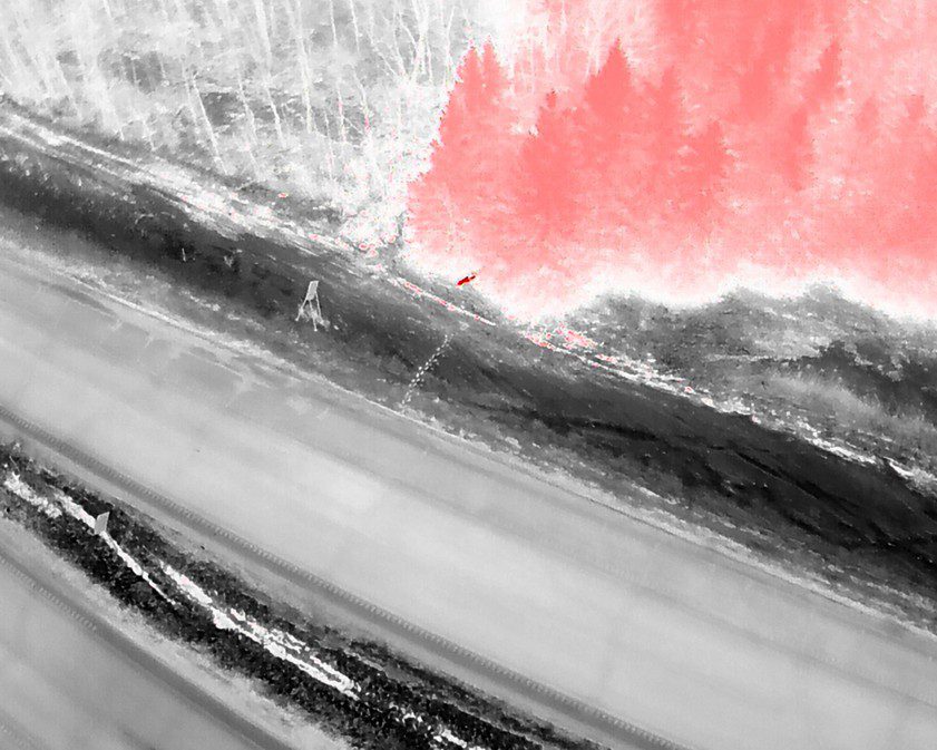
“You could see in that photo (above) where the pine trees, being dark needles, absorbed heat throughout the day, and they were glowing red. The birches and the aspens next door were still white. But fractions of a degree will show up on the drone,” explained Slatten. “So where that gentleman walked in the woods, his footprints were just a little bit warmer. Even his cane prints that he was walking with were visible on the video because they were just a little bit– a few degrees warmer than the surrounding snow.”
St. Louis Rescue Squad can also use their locate software to run drone footage through a processor that looks for a specific color.
“It’s particularly useful when we’re searching for deceased subjects because the heat signature might not be there,” explained Slatten. “So then we feed the video through a processor that looks for specific colors. And if we know what the guy was wearing, that’s also been a game changer for us.”
Drone technology is constantly evolving, and Slatten says this is not the end-all, be-all for search and rescue missions. Crucial information from the community is also helpful in search and rescue missions.
“The biggest thing is Ring/Arlo and other security cameras on your house. If we’re asking for help, there’s generally data that has suggested that the subject might be in this area,” emphasized Slatten. “We would like residents to check their security cameras. That has ended searches for us, where we’re working a point last scene and they give us a new point last scene that’s quite a bit more recent and puts us in the right area.”