Lea Zmurko: Bracing for the weekend weather
Here we go!
Starting this morning with some snow just north of the boarder, this system will build and drop into northern Minnesota by the mid-morning continuing to bring wintery precipitation across the rest of the region. Temperatures will continue to hover right near 32 degrees leading to more freezing rain and periodic rain showers and thunderstorms around the Northland
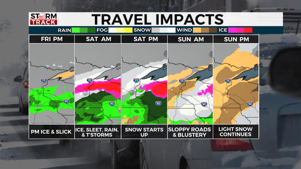
Freezing rain and icing remain as key threats for today and tonight closer to the lake. This incoming storm is mixing threats for both winter weather and spring storms as there is a likelihood for thunderstorms, hail accumulation and thunder snow later today. The risk for severe weather is heightened as quarter inch hail is possible over northwestern Wisconsin by the late afternoon as a cold front advances.
Snow will be more prominent in the second round, but for today it will remain up north on the international border with at most 4-5 inches and will taper off into light snowfall across the Iron Range. More snow is expected Saturday night into Sunday afternoon as the second wave of weather crosses over. Current models are indicating the heavy, wet snow will near and potentially exceed six inches along the South Shore and into northern Wisconsin, some snow will steer northward up the North Shore and fall in portions of east central Minnesota.
Looking ahead, there is still another chance for more winter weather sneaking into early April as another round of snow accumulation is setting up for the middle of next week.
Today
A chance of rain or freezing rain before 11am, then rain likely between 11am and 5pm, then rain and snow likely after 5pm. Cloudy, with a high near 35. Breezy, with an east wind 15 to 20 mph, with gusts as high as 30 mph. Chance of precipitation is 70%. Little or no ice accumulation expected. Little or no snow accumulation expected.
Tonight
Snow and freezing rain likely before 2am, then a slight chance of freezing rain and sleet between 2am and 4am, then a slight chance of freezing rain after 4am. Some thunder is also possible. Cloudy, with a low around 26. Breezy, with a northeast wind 15 to 20 mph, with gusts as high as 30 mph. Chance of precipitation is 70%. New ice accumulation of less than a 0.1 of an inch possible. Little or no snow and sleet accumulation expected.
Saturday
A slight chance of snow before 10am, then a chance of snow after 1pm. Cloudy, with a high near 32. Breezy, with an east wind around 15 mph, with gusts as high as 30 mph. Chance of precipitation is 30%.
Sunday
A 50 percent chance of snow. Patchy blowing snow between 8am and noon. Mostly cloudy, with a high near 34. Breezy, with a northeast wind 15 to 20 mph, with gusts as high as 30 mph. New snow accumulation of 1 to 2 inches possible.
Monday
Mostly sunny, with a high near 37. North wind around 10 mph, with gusts as high as 20 mph.
Tuesday
Partly sunny, with a high near 38. Breezy, with an east wind 5 to 15 mph, with gusts as high as 20 mph.
Wednesday
Snow likely, possibly mixed with rain. Patchy blowing snow. Mostly cloudy, with a high near 37. Breezy, with an east wind 15 to 20 mph, with gusts as high as 30 mph.
Thursday
A chance of snow. Partly sunny, with a high near 40. Breezy, with a northwest wind 10 to 15 mph becoming northeast in the afternoon. Winds could gust as high as 20 mph.