Lea Zmurko: Comfortable now, but chaos to come
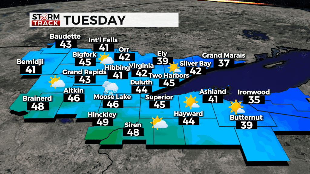
The Northland remains quiet with a ridge continuing to develop, temperatures will stay in the upper 40s and low 50s. Some clouds will pass across, but winds will remain light. Some showers will travel to the southwest of Brainerd Lakes, elsewhere remaining dry this afternoon.
The next few evenings remain chilly as the temperatures fall below freezing and some regions could see some light rain and snow fall but the accumulation at the surface remain negligible.
A messy winer system will cross the Borderlands on Friday afternoon and then another low will follow up across central MN and northern WI bringing mixed precipitation to the Northland over the weekend. There is still uncertainty on the tracks of these two systems as well as the timing of precipitation, but the system is slated to clear out by the start of next week.
Today
Mostly sunny, with a high near 44. Northwest wind around 5 mph.
Tonight
Partly cloudy, with a low around 23. North wind around 5 mph.
Wednesday
Mostly sunny, with a high near 48. West wind 5 to 10 mph, with gusts as high as 15 mph.
Thursday
Mostly sunny, with a high near 44. Northwest wind 5 to 10 mph becoming east in the afternoon. Winds could gust as high as 15 mph.
Friday
A chance of rain, snow, and freezing rain before 1pm, then rain likely, possibly mixed with snow. Mostly cloudy, with a high near 36. Breezy, with an east wind 15 to 20 mph, with gusts as high as 30 mph.
Saturday
A chance of snow, freezing rain, and sleet before 1pm, then snow and freezing rain likely. Mostly cloudy, with a high near 33. Breezy, with an east wind around 20 mph, with gusts as high as 30 mph.
Sunday
A chance of snow. Partly sunny, with a high near 35. Breezy, with a northeast wind 15 to 20 mph, with gusts as high as 30 mph.
Monday
Mostly sunny, with a high near 36. North wind around 10 mph, with gusts as high as 20 mph.