Lea Zmurko: Staying ready for the cold
As we start the week temperatures will be trending well below normal, and the Northland can be preparing for cold weather advisories as wind chill drop to near dangerously cold conditions overnight.
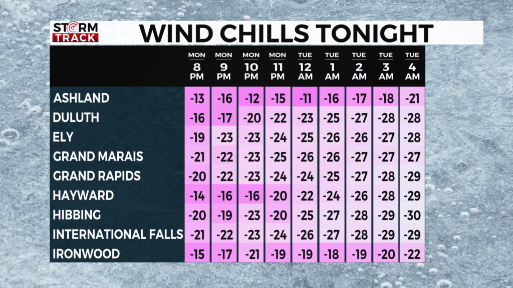
The coldest stretch will start this evening and continue into tomorrow as the overnight lows remain near ten below tonight. The westward winds will contribute to wind chills of near negative 30 degrees through Tuesday morning.
Chances for snow remain small but laker effect flurries will be spotted along the South Shore for the start of the week, the next chance for widespread accumulation will be Friday afternoon as a clipper stays just south of the Iron Range and crosses into northern Wisconsin.
Today
A chance of flurries after 3pm. Mostly sunny, with a high near 10. Breezy, with a west wind 10 to 15 mph, with gusts as high as 25 mph.
Tonight
A chance of flurries before 7pm. Partly cloudy, with a low around -21. Wind chill values between -25 and -35. Blustery, with a northwest wind 5 to 15 mph, with gusts as high as 20 mph.
Tuesday
Sunny and cold, with a high near 1. Wind chill values between -30 and -40. West wind 5 to 10 mph.
Wednesday
Mostly sunny, with a high near 9. West wind around 5 mph.
Thursday
Sunny, with a high near 7. West wind 5 to 10 mph, with gusts as high as 15 mph.
Friday
A chance of snow after noon. Mostly cloudy, with a high near 15. Southwest wind 5 to 10 mph becoming east in the afternoon. Winds could gust as high as 15 mph.
Saturday
A chance of flurries. Partly sunny, with a high near 14. North wind around 10 mph, with gusts as high as 20 mph.
Sunday
Mostly sunny and cold, with a high near 5. Northwest wind around 10 mph, with gusts as high as 20 mph.