Lea Zmurko: Tomorrow’s snow will switch up the arctic flow
The series of chilly morning continue as high pressure overhead continues to dominate. The clear skies and dense cold air allow for temperatures to fall well below zero seeing overnight lows dipping to – 30 degrees across the Northland. The light but consistent winds from the north add an additional chill to the region as a Cold Weather Advisory remains in effect until 10 AM this morning.
Temperatures will take a slight jump upwards Friday and Saturday as southeast winds come in ahead of the next blast of arctic air for Sunday and all next week.
With the few days of the weekend being slightly warmer than we have seen recently, the chances for snow are increasing. A clipper will cut across the area Friday afternoon and continue overnight bringing a couple inches from Brainerd to the Twin Ports and further east through out the northern tier of Wisconsin.
As the brief snow system clears out Saturday morning winds will remain favorable for South Shore Lake effect precipitation as the northwest flow allows for some slight snow accumulation across northeastern Wisconsin and the Upper Peninsula.
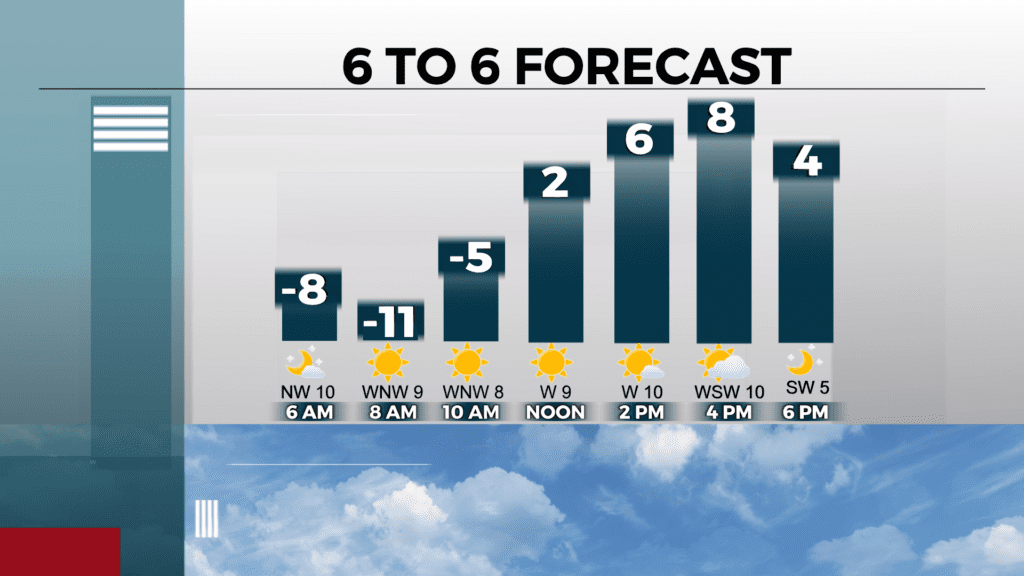
Today
Sunny, with a high near 6. Wind chill values between -25 and -35. Northwest wind 5 to 10 mph, with gusts as high as 15 mph.
Tonight
Partly cloudy, with a low around -10. West wind around 5 mph becoming south after midnight.
Friday
Snow, mainly after 3pm. High near 16. Southeast wind 5 to 10 mph, with gusts as high as 15 mph. Chance of precipitation is 90%. New snow accumulation of 1 to 3 inches possible.
Saturday
Partly sunny, with a high near 16. Blustery, with a north wind 10 to 15 mph, with gusts as high as 20 mph.
Sunday
Mostly sunny and cold, with a high near 1. Blustery, with a northwest wind 10 to 15 mph, with gusts as high as 20 mph.
Monday
Mostly sunny and cold, with a high near 1. Northwest wind 5 to 10 mph, with gusts as high as 15 mph.
Tuesday
Mostly sunny, with a high near 6. West wind around 10 mph, with gusts as high as 20 mph.
Wednesday
Mostly sunny, with a high near 9. Northwest wind around 10 mph, with gusts as high as 15 mph.