Track Hurricane Milton
Hurricane Milton continues to churn as it moves through the Gulf of Mexico toward Florida on Wednesday. Huge storm surge, destructive winds and heavy rain are major threats for Florida. Milton spent most of Tuesday as a Category 5, and early Wednesday morning weakened slightly to a Category 4. It is threatening the Tampa Bay area, which is home to more than 3.3 million people and has managed to evade a direct hit from a major hurricane for more than 100 years.
Milton is also menacing other stretches of Florida’s west coast that were battered when Helene came ashore on Sept. 26.
You can track the storm using the Interactive Radar below.
Original story Monday, October 7: Florida’s storm-battered Gulf Coast is bracing for another hit as Milton increased to a Category 5 hurricane on Monday. NOAA says the center of Hurricane Milton could come ashore Wednesday in the Tampa Bay region, which has not endured a direct hit by a major hurricane in more than a century.
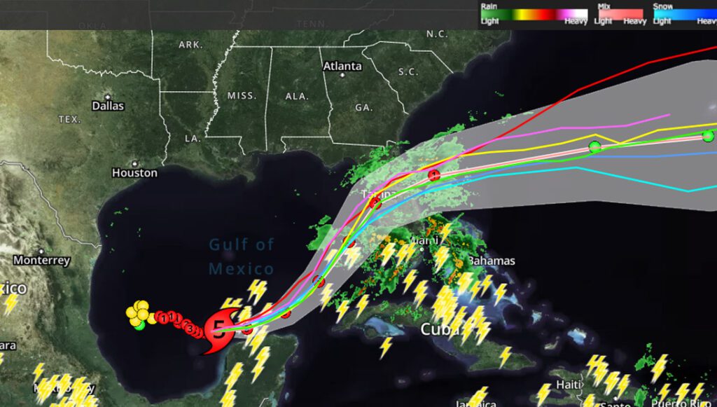
As evacuation orders were issued, forecasters warned of a possible 8- to 12-foot storm surge (2.4 to 3.6 meters) in Tampa Bay and widespread flooding from 5 to 10 inches (13 to 25 centimeters) of rain in mainland Florida and the Keys. As much as 15 inches (38 centimeters) could fall in places.
Scientists expect Milton to weaken slightly before making landfall, though it could retain hurricane strength as it churns across central Florida toward the Atlantic Ocean.
Residents in Florida, Georgia, North and South Carolina continue to work on clearing heaps of debris left over when Hurricane Helene made landfall as a Category 4 storm nearly two weeks ago. At least 230 people died in Helene’s path from Florida to the Appalachian Mountains.