Justin Liles: April Fools’ Day storm continues tonight
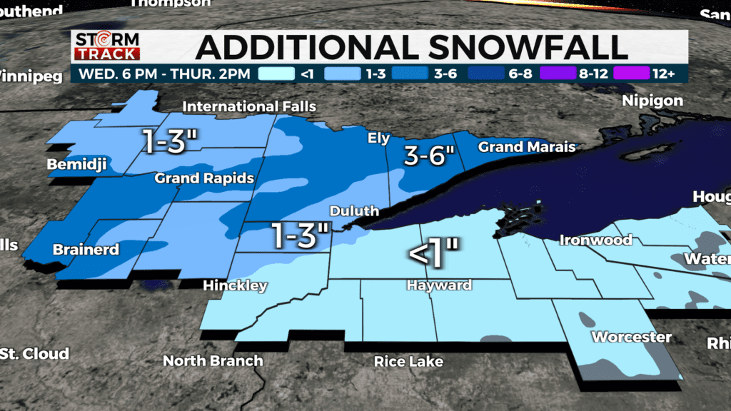
Poor Travel, along with accumulating snow, continues tonight. There is a Blizzard warning until 7 pm tonight for these reasons along the North Shore and Hwy 61. The heaviest snow and the worst part of the storm will be Wednesday afternoon through early tonight. Snow will be the main weather type for the Iron Range and higher terrain of the North Shore. Snowfall totals will be some of the highest we’ve had nearly all winter long. This is going to be a wet-heavy snow, so make sure to take it easy removing the mess. The wet-heavy content of the snow will help to limit the amount of snowfall totals in the region. Gusty winds off the lake will draw in drier air off the lake, which should limit the amount of snowfall too. The heaviest amount will likely be in the higher terrain of the north shore from Silver Bay up to Grand Portage.
High winds along the shoreline are creating Blizzard Conditions and poor travel. Visibilities are extremely low, making it hard to drive.
Before you head out, please check travel conditions or school cancellations for your area. Snow and winds will gradually let up heading into Wednesday night and Thursday morning. Drier conditions return for the weekend.
TONIGHT
Snow likely, possibly mixed with rain and freezing rain, becoming all snow after 11 pm. Cloudy, with a low around 27. Breezy, with an east wind 10 to 15 mph becoming west after midnight. Winds could gust as high as 25 mph.
THURSDAY
Mostly cloudy, with a high near 42. Breezy, with a west wind 10 to 15 mph, with gusts as high as 25 mph.
FRIDAY
Partly sunny, with a high near 44. Calm wind becoming southwest around 5 mph in the afternoon.
SATURDAY
Mostly sunny, with a high near 41. Breezy, with a northwest wind 10 to 15 mph, with gusts as high as 20 mph.
SUNDAY
Mostly sunny, with a high near 37. Breezy, with a northwest wind 10 to 15 mph, with gusts as high as 25 mph.
MONDAY
Mostly sunny, with a high near 37. Northwest wind around 10 mph, with gusts as high as 20 mph.