Justin Liles: Strong winds for all & some snow for others tonight

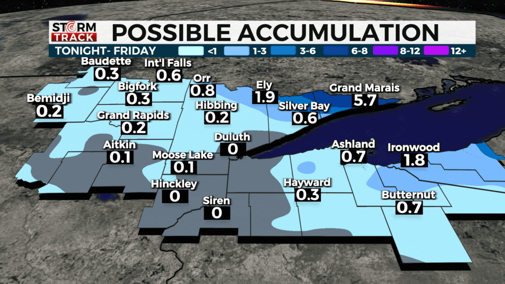
A strong but somewhat moisture starved clipper will move through the region tonight into Friday bringing snow for the Minnesota Arrowhead and a rain/snow mix elsewhere. Snow amounts with the clipper will be greatest in the Arrowhead where 3-6 inches are expected with maybe a little more in higher elevations and near Grand Portage. Lower elevation areas near Two Harbors should see less than an inch.
Overnight wind will begin to pick up and be extremely the moment you open the door tomorrow morning. Winds will be sustained out the north-northwest 25-35mph with gust exceed 40mph. High profile vehicles show take it easy going over the Bong and Blatnik bridges. Lake effect snow for the south shore will take over heading Friday night into Saturday. Dry and cooler Saturday before warming back up heading into the new week. Next chance of precipitation arrives Monday night. A mix of rain and snow is forecast.
Tonight
A wintry mix and getting breezy, with a west wind 5 to 10 mph becoming west 15 to 20 mph after midnight. Winds could gust as high as 35 mph.
Friday
A chance of rain and snow before noon, then a wintry mix to follow, Mostly cloudy, with a temperature falling to around 26 by 5pm. Windy, with a north wind 15 to 25 mph, with gusts as high as 40 mph.
Saturday
Sunny, with a high near 22. Northwest wind 5 to 10 mph, with gusts as high as 15 mph.
Sunday
Mostly sunny, with a high near 34. Southwest wind 5 to 10 mph, with gusts as high as 15 mph.
Monday
Mostly sunny, with a high near 45. South wind 5 to 10 mph, with gusts as high as 15 mph.
Tuesday
Rain likely, possibly mixed with snow, mainly before noon. Mostly cloudy, with a high near 40. Northeast wind 5 to 10 mph, with gusts as high as 15 mph.
Wednesday
A chance of snow. Partly sunny, with a high near 33. Breezy, with a north wind 10 to 15 mph, with gusts as high as 25 mph.
Thursday
Mostly sunny, with a high near 34. West wind around 10 mph, with gusts as high as 20 mph.