Lea Zmurko: A few fair days before the next storm
A little bit of light rain and snow quickly scatters across Northern Minnesota this morning, nothing much will accumulate at the surface, but clouds will be passing overhead. The rest of today remains dry with moderate winds from the west continuing to keep cloud coverage moving.
Temperatures will climb into the upper 40s, and skies will be sunny and bright for many until Thursday afternoon. If any light flakes do make it down to the ground in the early morning, it will quickly melt from the rising temperatures. With dry skies today and tomorrow, the increasing winds will pose a threat to wildfires so burn restrictions will likely continue.
Looking ahead, a series of two large systems will barge into the Northland for the weekend bringing a wide variety of precipitation and gusty conditions. Rain, ice and snow are all expected around the different regions as this double whammy weather event works its way in.
It will start up north late Thursday night and sink south across the Iron Range bringing freezing rain and sleet to northern Minnesota on Friday. Temperature gradients will be the key for the distinction between rainfall and ice accumulation as surface temperatures will be very impactful on the precipitation types observed. There will be a short break Friday night into Saturday morning as the second system works its way northward with mixed precipitation and heavy snow for the north shore and northern Wisconsin by Sunday morning. The coast will be clear by Sunday evening and we will start next week with a few quiet days.
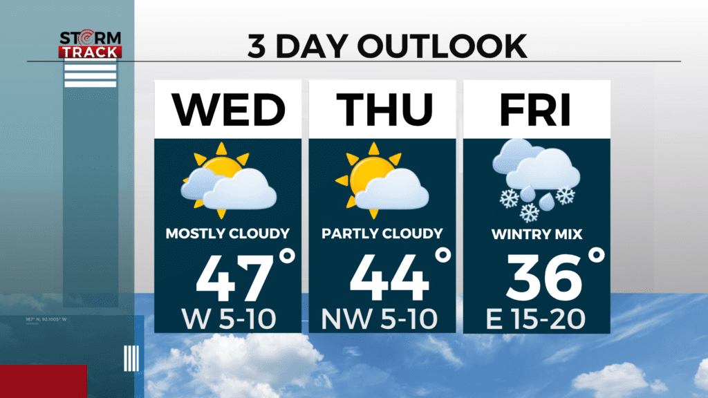
Today
A slight chance of snow before 7am, then a chance of flurries between 7am and 8am. Partly sunny, with a high near 48. West wind 5 to 10 mph, with gusts as high as 15 mph. Chance of precipitation is 10%.
Tonight
Partly cloudy, with a low around 29. West wind 5 to 10 mph, with gusts as high as 20 mph.
Thursday
Sunny, with a high near 43. Northwest wind 5 to 10 mph becoming east in the afternoon.
Friday
Rain or freezing rain likely before 10am, then rain. High near 36. Breezy, with an east wind 15 to 20 mph, with gusts as high as 30 mph. Chance of precipitation is 80%. New precipitation amounts between a tenth and quarter of an inch possible.
Saturday
A chance of snow, mainly after 1pm. Mostly cloudy, with a high near 34. Breezy, with a northeast wind around 15 mph, with gusts as high as 30 mph.
Sunday
A slight chance of snow. Partly sunny, with a high near 36. Breezy, with a northeast wind around 15 mph, with gusts as high as 20 mph.
Monday
Mostly sunny, with a high near 37. Northeast wind around 10 mph, with gusts as high as 20 mph.
Tuesday
Mostly sunny, with a high near 40. Southeast wind 5 to 10 mph, with gusts as high as 20 mph.