Lea Zmurko: A mild moment ahead of more snow and arctic air
A few more clippers will cross the Northland in the coming evenings, accumulation will remain minimal through Friday but a dusting across the Borderlands, Arrowhead and eventually the South Shore is likely.
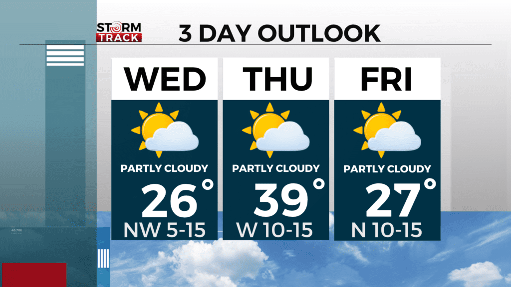
Temperatures will continue to remain above normal during the dayparts with dry conditions sticking to the mid-20s today and returning to the upper thirties and low forties tomorrow. Cooler air will arrive for the start of February and temps will return to below normal with highs in the low teens.
The better chances for snowfall will occur over the weekend with a moist system arriving Saturday afternoon and clearing by Sunday evening. This will easily bring 3-6 inches of snow across the area, and some will see greater amounts down by the lake.
Today
Mostly sunny, with a high near 26. Blustery, with a northwest wind 5 to 15 mph, with gusts as high as 30 mph.
Tonight
A slight chance of snow between 8pm and midnight. Cloudy, then gradually becoming partly cloudy, with a steady temperature around 22. Southwest wind 5 to 10 mph. Chance of precipitation is 20%.
Thursday
Sunny, with a high near 38. West wind around 10 mph, with gusts as high as 15 mph.
Friday
Partly sunny, with a high near 27. North wind around 10 mph, with gusts as high as 15 mph.
Saturday
Snow likely, mainly after noon. Cloudy, with a high near 26. Breezy, with an east wind 10 to 15 mph, with gusts as high as 20 mph.
Sunday
A chance of snow. Mostly cloudy, with a high near 32. Breezy, with a southeast wind 5 to 15 mph becoming west in the afternoon. Winds could gust as high as 20 mph.
Monday
Mostly cloudy, with a high near 14. Blustery, with a northwest wind 10 to 15 mph, with gusts as high as 25 mph.
Tuesday
Partly sunny, with a high near 12. West wind around 10 mph, with gusts as high as 15 mph.