Lea Zmurko: A warm wrap up to September
A few patches of fog will clear mid-morning as the sun rises. Visibility remains close to a quarter mile in parts of central Minnesota and northwestern Wisconsin. As the sun rises the unseasonable warm weather continues this afternoon with temperatures in the mid to upper 70s. Tonight will be cool and clear providing another opportunity to spot the Northern Lights across the region.
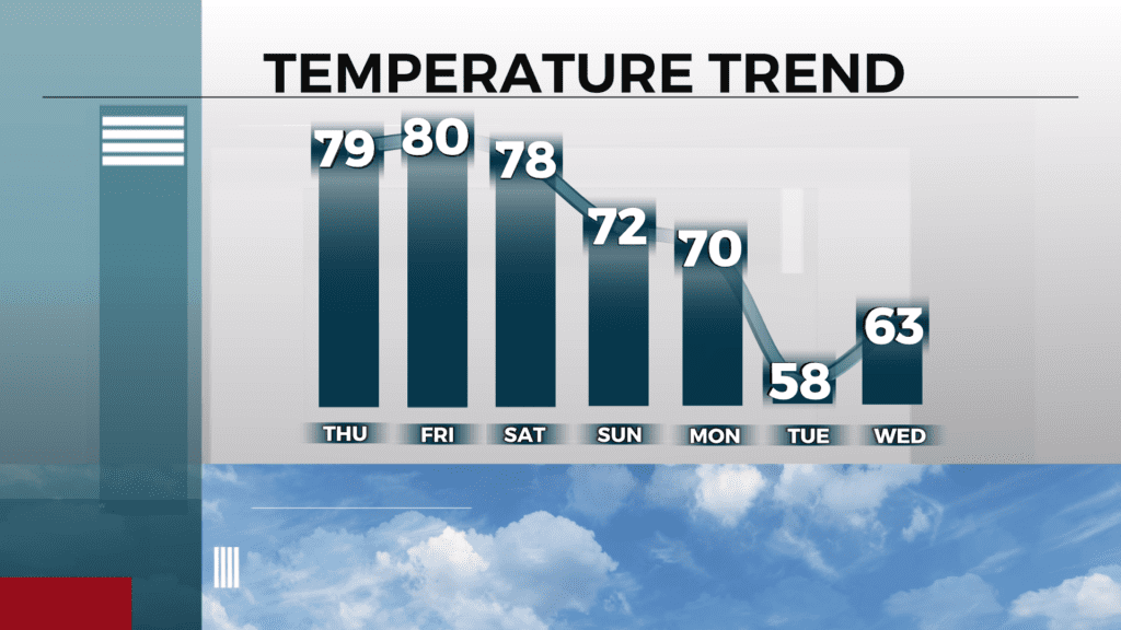
Dry weather continues through Monday ahead of the incoming cold front. We will see a few evening showers at the start of next week as temperatures start to drop into the upper 50s and low 60s for the start of October. With the cooler air moving in, the chances for overnight frosts continue with lows in the 30s.
Today
Sunny, with a high near 79. Northwest wind around 5 mph becoming southeast in the afternoon.
Tonight
Mostly clear, with a low around 53. East wind around 5 mph becoming southwest after midnight.
Friday
Sunny, with a high near 81. West wind around 5 mph.
Saturday
Sunny, with a high near 76. Calm wind becoming east around 5 mph in the afternoon.
Sunday
Sunny, with a high near 72. East wind 5 to 10 mph, with gusts as high as 15 mph.
Monday
Mostly sunny, with a high near 75. Breezy, with a south wind 5 to 15 mph becoming west in the afternoon. Winds could gust as high as 20 mph.
Tuesday
A slight chance of showers. Mostly sunny, with a high near 58. Breezy, with a west wind 10 to 15 mph, with gusts as high as 20 mph.
Wednesday
Mostly sunny, with a high near 63. Breezy, with a south wind 10 to 15 mph, with gusts as high as 25 mph.