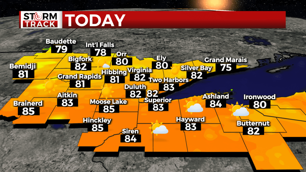
Lea Zmurko: It’s relief from rain, but a scorcher of a day!
A quiet start to the morning as the remaining rainfall and storms exited eastward in the early morning. A few areas with some fog as the relative humidity starts at a high for the morning. This will diminish as the solar heating today continues.
Monday night brought in heavy rainfall for regions across northwest Wisconsin leading to flash flooding warnings in southern parts of Bayfield, Ashland, and Douglas counties and northern parts of Sawyer and Washburn as well.
Clear day ahead with temperatures marching upwards of 80 degrees. The clouds coverage will increase in the late afternoon with a few passing showers moving across the Borderlands in the overnight. Some overnight showers can also be anticipated in the Brainerd Lakes region due to a short-wave trough moving across in the upper levels of the atmosphere. But no strong or severe weather is expected for today in the Northlands.
With mostly fair weather in the next stretch, there will also be a chance for some isolated events of rain in the upcoming afternoons. Temperatures will fall to into the upper 60s low 70 as conditions mild out for the rest of the work week as cloud coverage will increase in many regions. A greater chance for thunderstorms will return come Thursday evening and will likely resurge on Friday as a cold front move through chances for strong to severe storms will be possible with timing and convection are permitting.
Today
Sunny, with a high near 79. Breezy, with a west wind 10 to 15 mph, with gusts as high as 25 mph.
Tonight
Mostly clear, with a low around 54. Breezy, with a west wind 5 to 15 mph becoming north after midnight. Winds could gust as high as 20 mph.
Wednesday
Mostly sunny, with a high near 66. Northeast wind 5 to 10 mph.
Thursday
Mostly sunny, with a high near 70. Light and variable wind becoming south 5 to 10 mph in the morning.
Friday
Showers and possibly a thunderstorm. Mostly cloudy, with a high near 67. Breezy, with a southeast wind around 15 mph, with gusts as high as 25 mph.
Saturday
A slight chance of showers, with thunderstorms also possible after 1pm. Mostly sunny, with a high near 66. Breezy, with a west wind around 15 mph, with gusts as high as 25 mph.
Sunday
Sunny, with a high near 67. Northwest wind around 5 mph becoming southeast in the afternoon.
Monday
Showers likely. Partly sunny, with a high near 66. Breezy, with a southeast wind 10 to 15 mph, with gusts as high as 25 mph.