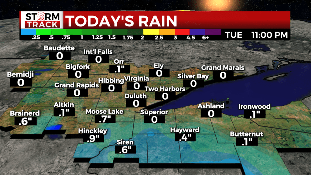
Lea Zmurko: Tuesday morning thunderstorms
A system of strong thunderstorms moved eastward across central Minnesota into northern Wisconsin this morning. No severe weather is expected, but the storms are bringing strong winds, heavy wind and cloud-to-ground lightning across the region.
More isolated severe thunderstorms are slated to arrive Wednesday evening into the early hours of Thursday morning. The key hazards include damaging winds, large hail, and locally heavy rain with risks for flooding.

Humid conditions will also be lasting this week as dewpoints remain in the 60s through the evening. This moisture in the air is keeping the environment muggy and uncomfortable today. The high dewpoints are also a contributing factor to the dense fog lingering across northern Wisconsin this morning.
With a south wind, the warm temperatures are set to continue throughout the work week. Temperatures reaching widespread 90s by the weekend. Conditions will also continue to dry out then and the heat is forecasted to break by early next week as a deep trough moves in.
Today
A 30 percent chance of showers and thunderstorms, mainly before 3pm. Partly sunny, with a high near 83. Calm wind becoming southeast around 5 mph in the afternoon.
Tonight
Mostly clear, with a low around 66. East wind around 5 mph becoming calm.
Wednesday
Patchy fog before 7am. Otherwise, mostly sunny, with a high near 86. Calm wind becoming southeast around 5 mph in the morning.
Thursday
A 40 percent chance of showers and thunderstorms. Partly sunny, with a high near 84. Northwest wind 5 to 10 mph.
Friday
Sunny and hot, with a high near 90. Northwest wind 5 to 10 mph, with gusts as high as 15 mph.
Saturday
Sunny, with a high near 87. West wind 5 to 10 mph, with gusts as high as 15 mph.
Sunday
A slight chance of showers and thunderstorms. Mostly sunny, with a high near 79. Northeast wind 5 to 10 mph.
Monday
A slight chance of showers. Partly sunny, with a high near 80. Northwest wind 5 to 10 mph becoming south in the afternoon. Winds could gust as high as 15 mph.