Sabrina Ullman: Slick, snowy Sunday
Snow has been staying primarily towards the international border today due to more dry air than anticipated moving into the Twin Ports area. More moisture in the region will result in a return of snow chances this evening.
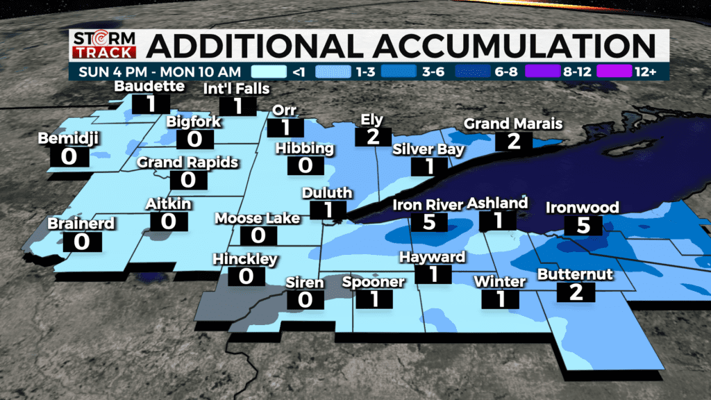
There will likely be a narrow band of heavy snow in the higher terrain of Bayfield County tonight into early Monday morning as well as lake-effect snow in Iron County and the U.P. These areas can expect 3-6 inches of additional accumulation while the rest of the Northland gets under three inches.
Slick travel is expected until midday Monday. We will see skies start to clear on Monday, and this week will have quiet weather from Monday afternoon to Thursday night. There is potentially another messy storm heading our way Friday-Saturday.
Today
Snow likely before 8 am, then snow likely, possibly mixed with freezing rain between 8 am and 9 am, then snow after 9 am. High near 37. Breezy, with an east wind of 10 to 15 mph becoming northwest in the afternoon. Winds could gust as high as 20 mph. The chance of precipitation is 90%. Little or no ice accumulation is expected. New snow accumulation of 1 to 3 inches is possible.
Tonight
Snow is likely, mainly before 7 pm. Cloudy, with a low around 21. Blustery, with a northwest wind around 15 mph, with gusts as high as 30 mph. The chance of precipitation is 60%. New snow accumulation of less than one inch is possible.
Monday
Mostly cloudy, then gradually becoming sunny, with a high near 37. Breezy, with a northwest wind of 10 to 15 mph, with gusts as high as 25 mph.
Tuesday
Partly sunny, with a high near 39. Northwest wind around 5 mph.
Wednesday
Mostly sunny, with a high near 42. West wind 5 to 10 mph, with gusts as high as 20 mph.
Thursday
Partly sunny, with a high near 40. Northwest wind around 10 mph becoming east in the afternoon. Winds could gust as high as 15 mph.
Friday
A chance of rain and snow. Partly sunny, with a high near 38. Breezy, with an east wind around 15 mph, with gusts as high as 25 mph.
Saturday
Rain, snow, and freezing rain are likely. Mostly cloudy, with a high near 40. Breezy, with a northeast wind of around 15 mph, with gusts as high as 30 mph.