Sabrina Ullman: Mostly snow for our Sunday
Snow will become fluffier as the day goes on. We might see some freezing rain today from Burnett to Pine County, but for the most part, snow will be the only precipitation type. Afternoon highs will be in the 30s.
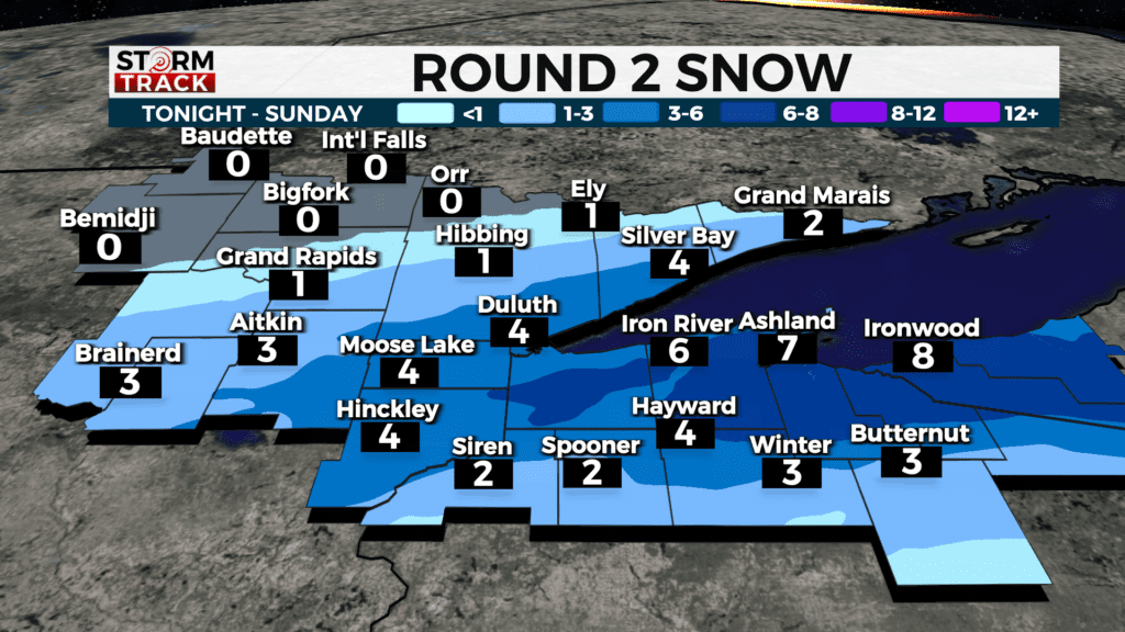
This system will exit west to east and be fully out of the Northland by 8 pm tonight. We will have a brief break from snow with sunny skies on Monday.
Another round will enter the region Tuesday night, becoming widespread on Wednesday. The Storm Track Weather Team will have snowfall totals for Wednesday as it gets closer, but it is currently looking like widespread 4-6 inches or more.
Today
Snow, mainly before 11 am. Patchy blowing snow between 10 am and 1 pm. High near 33. Breezy, with a northeast wind of 15 to 20 mph, with gusts as high as 30 mph. The chance of precipitation is 80%. New snow accumulation of less than one inch is possible.
Monday
Sunny, with a high near 35. North wind around 10 mph, with gusts as high as 20 mph.
Tuesday
A slight chance of snow after 1 pm. Partly sunny, with a high near 37. Breezy, with a southeast wind 5 to 15 mph, with gusts as high as 25 mph.
Wednesday
Snow before 1 pm, then snow, possibly mixed with rain. The snow could be heavy at times. Patchy blowing snow. Mostly cloudy, with a high near 38. Breezy, with an east wind of around 20 mph, with gusts as high as 35 mph.
Thursday
Partly sunny, with a high near 43. Northwest wind around 10 mph, with gusts as high as 20 mph.
Friday
Mostly sunny, with a high near 45. South wind 5 to 10 mph, with gusts as high as 15 mph.
Saturday
A slight chance of rain. Mostly sunny, with a high near 47. Breezy, with a northwest wind 10 to 15 mph, with gusts as high as 20 mph.