Sabrina Ullman: Severe thunderstorms possible tonight
.")
Severe thunderstorms are possible tonight (WDIO).
After a dry couple of days, rain chances return tonight. Strong thunderstorms are likely between 10 pm and 9 am, mostly in the Boundary Waters area. Some thunderstorms may become severe and have wind gusts up to 70 mph and hail up to 1.5” in diameter.
Monday will be another hot and humid day, but there will not be a lake breeze to help keep some areas cooler this time. Afternoon highs will be in the 80s, and heat index values will climb to the 90s for areas south of the Twin Ports. If you are going to the Minnesota State Fair, the heat index will be around 100 degrees at noon.
A Heat Advisory has been issued for Pine, Douglas, Washburn, Burnett, Sawyer, Ashland, Iron, and Price Counties from 1 pm to 8 pm Monday. South of these counties, there is currently a Heat Advisory in effect until 1 pm Monday that will be upgraded to an Excessive Heat Warning from 1 pm to 8 pm Monday. This warning includes the Twin Cities.
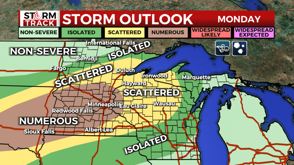
The heat alongside all the moisture in the atmosphere will increase the risk of severe weather as a cold front enters the region Monday. A second round of thunderstorms is expected Monday night into Tuesday morning with numerous storms becoming severe. The risk will cover a larger area, and heavy rain is possible in addition to damaging winds and large hail.
Rain will continue into Tuesday. The good news is that we can see the light at the end of the tunnel regarding dangerous heat. Tuesday will have afternoon highs in the upper 60s to low 70s. To put this into perspective, Tuesday’s highs will be around what our overnight lows will be tonight. Cooler temperatures will continue for the rest of the week with another cold front likely Thursday night.
Tonight
A 20 percent chance of showers after 3am. Patchy fog after 1am. Otherwise, mostly cloudy, with a low around 65. East wind 5 to 10 mph.
Monday
A chance of showers and thunderstorms before noon, then a slight chance of showers and thunderstorms after 4pm. Areas of fog before 9am. Otherwise, partly sunny, with a high near 85. North wind around 5 mph. Chance of precipitation is 30%.
Monday Night
A slight chance of showers and thunderstorms, then showers and possibly a thunderstorm after 7pm. Some of the storms could be severe. Patchy fog between 10pm and 11pm. Low around 64. North wind around 5 mph. Chance of precipitation is 80%. New rainfall amounts between three quarters and one inch possible.
Tuesday
Showers likely and possibly a thunderstorm. Mostly cloudy, with a high near 72. Northeast wind 5 to 10 mph, with gusts as high as 20 mph. Chance of precipitation is 70%. New rainfall amounts between a half and three quarters of an inch possible.
Wednesday
Partly sunny, with a high near 68. East wind 5 to 10 mph, with gusts as high as 20 mph.
Thursday
Showers likely and possibly a thunderstorm. Mostly cloudy, with a high near 69. East wind around 10 mph becoming south in the afternoon. Winds could gust as high as 20 mph.
Friday
Sunny, with a high near 74. Breezy, with a west wind 10 to 15 mph, with gusts as high as 25 mph.
Saturday
Sunny, with a high near 75. Breezy, with a west wind 10 to 15 mph, with gusts as high as 20 mph.
Sunday
Sunny, with a high near 68. Northwest wind around 10 mph, with gusts as high as 20 mph.