Sabrina Ullman: Storms and snow to end the week
Today is Pi Day, but it is also unofficially “false spring” for the Northland. Afternoon highs will range from the 40s near the lake to the low 70s south of the Twin Ports.
A few light showers are likely in the morning to early afternoon. Then, as a strong low-pressure system enters the region, rain will become widespread and heavy overnight. Rainfall amounts will range from about a quarter of an inch in the Hayward area to over an inch in areas northwest of the Iron Range. Heavy rain will likely cause ponding issues, especially in areas with snow on the ground.

There is potential for severe thunderstorms tonight south of Highway 2. Damaging winds will be the main risk, but large hail is also in the realm of possibility.
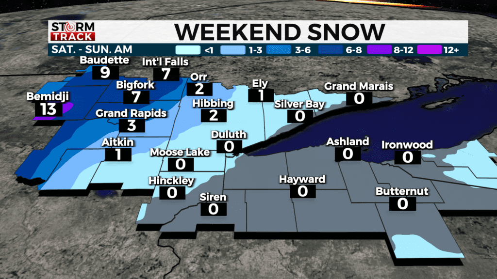
Rain will transition to snow on Saturday, with freezing rain possibly in the morning. Ice accumulation of up to half an inch is possible in the Bemidji area. As for the snow, the vast majority of accumulation will be in the western portion of Minnesota stretching into North Dakota.
Most of the Northland will have under an inch of snow. Areas along the Iron Range will have 1-3 inches of accumulation. International Falls and other areas in Koochiching County will have 6-8 inches of snow.
Once this system exits on Saturday evening, winds will pick up and stay gusty for the remainder of the weekend. Cooler conditions will begin on Sunday as we have highs in the 30s to low 40s throughout the upcoming week.
Today
Partly sunny, with a high near 55. Breezy, with an east wind 10 to 15 mph, with gusts as high as 20 mph.
Tonight
Rain and thunderstorms likely, then rain after 4am. Low around 42. East wind around 10 mph, with gusts as high as 20 mph. Chance of precipitation is 80%. New rainfall amounts between a tenth and quarter of an inch, except higher amounts possible in thunderstorms.
Saturday
Rain likely before 4pm, then a chance of snow. Mostly cloudy, with a high near 46. Breezy, with an east wind 5 to 10 mph becoming northwest 15 to 20 mph in the afternoon. Winds could gust as high as 35 mph. Chance of precipitation is 60%. Little or no snow accumulation expected.
Sunday
Sunny, with a high near 32. Breezy, with a northwest wind 15 to 20 mph, with gusts as high as 30 mph.
Monday
A slight chance of snow before 1pm. Partly sunny, with a high near 41. East wind 5 to 10 mph, with gusts as high as 15 mph.
Tuesday
A chance of snow. Mostly cloudy, with a high near 40. Breezy, with a northeast wind 10 to 15 mph, with gusts as high as 25 mph.
Wednesday
A chance of snow. Mostly cloudy, with a high near 35. Breezy, with a north wind around 15 mph, with gusts as high as 25 mph.
Thursday
Mostly sunny, with a high near 34. Breezy, with a northwest wind around 15 mph, with gusts as high as 25 mph.