Sabrina Ullman: Wonderful weather before a wintry mix
Tonight will have passing clouds and overnight lows in the 20s to low 30s. Light rain is possible in the Brainerd area, but the weather will be otherwise quiet in the area until Thursday night.
Thursday will be sunny with afternoon highs in the 40s to low 50s. You will want to get out and enjoy this day before messy weather heads our way.
The first round of precipitation will enter the area midday on Friday, bringing a mixture of rain, freezing rain, and sleet. It will also be breezy with an east wind of 15-25 mph. Ice accumulation of up to a quarter of an inch will be likely for the Arrowhead region.
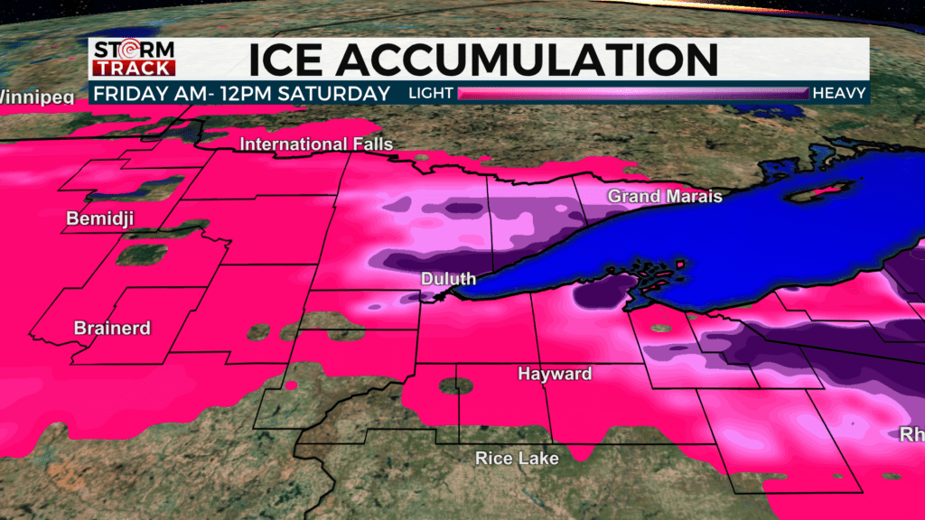
A Winter Storm Watch has been issued for Cook, Lake, and Carlton Counties as well as the central and southern portions of St. Louis County. This will be in effect from late Thursday night until early Saturday morning.
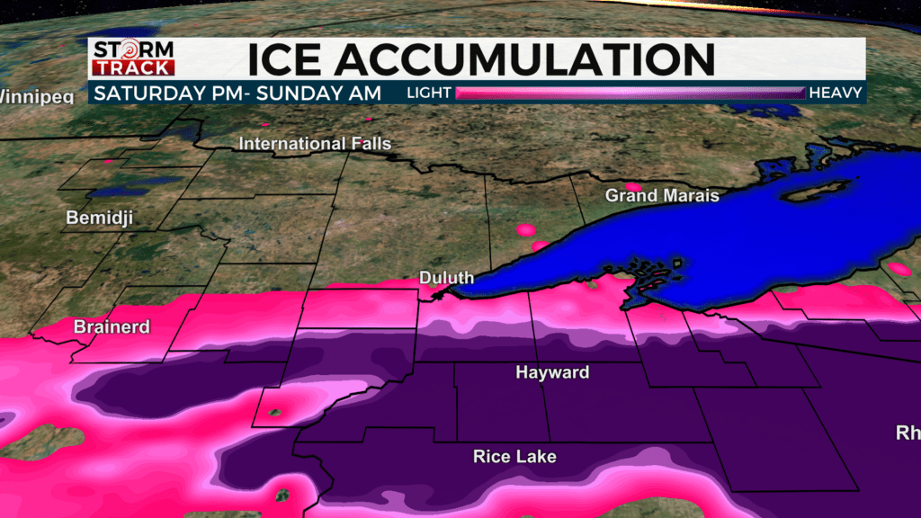
We will get a break from precipitation on Saturday morning but then have another round in the evening. This round will be mostly snow with some freezing rain and is expected to be towards the Twin Ports and further south. Ice accumulations up to a quarter of an inch will be likely for areas in northern Wisconsin.
Tonight
Partly cloudy, with a low of around 27. West wind 5 to 10 mph, with gusts as high as 15 mph.
Thursday
Sunny, with a high near 45. Northwest wind 5 to 10 mph becoming east in the afternoon.
Friday
Rain or freezing rain is likely before 10 am, then rain. High near 35. Breezy, with an east wind of around 15 mph, with gusts as high as 30 mph. The chance of precipitation is 80%. New precipitation amounts to less than a tenth of an inch possible.
Saturday
A chance of snow, mainly after 1 pm. Mostly cloudy, with a high near 32. Blustery, with a northeast wind around 15 mph, with gusts as high as 30 mph.
Sunday
A slight chance of snow. Partly sunny, with a high near 35. Breezy, with a northeast windof around 15 mph, with gusts as high as 25 mph.
Monday
Mostly sunny, with a high near 37. Northeast wind around 10 mph, with gusts as high as 15 mph.
Tuesday
Mostly sunny, with a high near 40. Southeast wind 5 to 10 mph, with gusts as high as 20 mph.