Weatherz School: Thunderstorm cap

On a warm day, a clear sky can quickly be replaced by a towering thunderstorm that ruins outdoor plans. Thunderstorm forecasting is complex, but there is a critical factor that may determine whether a golfer keeps a scheduled tee-time or a baseball game makes it through nine innings. It’s called the cap. So, what is it?
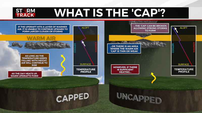
It’s all about how the temperature changes with height. In general, air is warmest at the surface and gradually becomes cooler the higher up you go. Air rises as long as the surrounding air is cooler. As the day heats up, rising air creates warm updrafts. As long as the temperature keeps falling with height, air will continue to rise.
If the updraft hits a layer air where the temperature rises with height, it’s unable to continue upward. This warm layer is the cap. If a cap stops the upward motion, large cumulonimbus clouds are not able to form.
However, if there is sufficient heating, or if the warm air layer is thin or weak, the cap can be broken. When that happens, the updraft can continue to grow and strong thunderstorms can form.
Think of it as a pot of boiling water. If we put a lid on the pot and turn the heat down, the lid, or cap, keeps the energy contained. But if the water boils over, the energy overcomes the cap and we’ve got a mess to clean up.
As a meteorologist, a key part of forecasting thunderstorm development is looking at the temperature profile of the atmosphere and determining whether or not the environment will allow the cap to be broken; is the pot going to boil over. It’s a complex phenomenon that forecast models can have a hard time pinning down.
So, next time the forecast calls for storms but you end up being able to keep your plans, thank the cap.